Editor’s note: Due to recent rainfall levels, many area hiking trails are currently closed due to hazardous flooding and debris. Before going, please confirm the trail is open and safe for hiking. Please check back as conditions improve.
Santa Barbara’s majestic wilderness areas abound with unexpected finds and hidden gems—including some wonderful waterfalls. Four of our falls are relatively easy to access for beginning to intermediate hikers. When it comes to the size and power of the falls, they change in intensity based on the season and current rain levels. Fortunately, regardless of how much water is flowing, the journey is as pleasant as the destination all year-round. So, lace up your sneakers—or hiking boots—and hit one of these invigorating trails. And don’t forget to hashtag #SeeSB!
Image via Instagram @mayley_debernardi
Nojoqui Falls
Nojoqui Falls is a great option for the whole family. You can make a whole day of relaxing in the park, taking advantage of the barbecue pits, picnic tables and playing fields—a game of bocce ball or horseshoes anyone? It’s also worth noting that this is the only falls with a restroom near the trailhead. The short hike to the 80-foot falls winds up a shaded canyon along a well maintained and easy-to-navigate trail. It’s just over a quarter of a mile each way and takes all of 20 minutes there and back. The falls are at their prime in spring and there’s at least a trickle all year round. While you don’t really need turn-by-turn directions since there’s one clearly marked path, this is how the gentle hike unfolds:
– Follow the wide trail, walking among oaks and laurels.
– At the halfway point, the trail enters the canyon below the falls.
– Cross the wooden bridge and climb the stone steps on the left bank of the creek.
– The trail will crisscross the canyon and deliver you to the viewing platform at the base of the falls.
Trailhead Location: Nojoqui Falls Park, north of the Gaviota Tunnel and close to Buellton Challenge Level: Easy Length: Less than 1 mi/1 km
Image via Instagram @kngjamesg
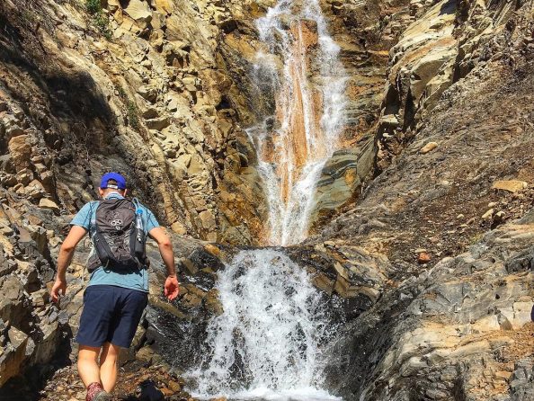
Tangerine Falls
In season, Tangerine Falls is Santa Barbara’s biggest at 100-feet. It also happens to be the most challenging to reach. Don’t let that scare you off if you’re in good shape, have the right footwear and are not daunted by some bouldering! Between crossing the creek several times and climbing boulders at the very end to get to the base of the falls, this Montecito trail requires some agility. Once you reach the falls, take in the sweeping views down the canyon and get a glimpse of the Pacific. Please note that the conditions for this hike are optimal March through November, and it can be very dangerous during wet periods. Here’s what you can expect:
– Start at the main Cold Spring Trail head.
– You’ll immediately climb up steep, wooden steps and walk along a creek.
– About a quarter-mile in, you’ll come across a bench and a signed junction for the West Fork of the Cold Spring Trail. Go to the left and cross the creek.
– You’ll continue uphill, as the trail follows a water pipe.
– When you’ve gone almost one mile, you’ll come to a junction with a giant boulder to the right and one straight ahead. Take the fork on the right heading down and criss-cross the creek.
– Once you reach the falls themselves, carefully climb the slick rocks to the base.
Trailhead Location: Cold Spring Trail sign on East Mountain Drive in Montecito Challenge Level: Difficult Length: 2.5 mi/4 km
Image via Instagram @lost.sasquatch
Seven Falls
Seven Falls is a classic Santa Barbara front country hike starting from the same trailhead as Inspiration Point. This mildly challenging out and back route takes you into the Los Padres National Forest, where you’ll pass creeks and hop boulders en route to the falls. Stopping to splash and play in the pools is optional! Here’s how to find your way there:
– Pass through the locked gate and follow Edison Road.
– After about a quarter of a mile, cross the wooden bridge.
– When you reach the dirt road, stay straight on the dirt road and continue straight past the Tunnel Trail sign.
– Veer left onto the Jesusita Trail and follow that until you reach a creek.
– Leave the Jesusita Trail here and turn right up the creek.
– Expect to get your feet wet and do some boulder hopping as you make your way to the falls, which are the end of the trail.
Trailhead Location: Tunnel Road in Santa Barbara just above the Santa Barbara Botanic Garden Challenge Level: Moderate Length: 3.2 mi/5.1 km
Image via Instagram @joshuam_
San Ysidro Falls
Head into the foothills of Montecito in pursuit of San Ysidro Falls. The mostly uphill hike goes for about 1.75-miles along the well-signed San Ysidro Trail before reaching the falls. After a big rain, the falls are a dramatic sight to behold. In drier months, it’s pretty chill and peaceful as can be. Here’s how to get there:
– Start at San Ysidro Trail sign.
– Just shy of a quarter of a mile in, you’ll join paved-road and turn left.
– When the pavement ends at a heavy gate, continue through the gate and follow the dirt road.
– Before you’ve hit the one-mile mark, the trail will leave the road.
– Look for the redwood tree with a small commemorative rock marker below, and turn right onto the trail.
– You’ll cross one large creek and at around 1.75 miles in, take the side trail to the waterfall.
Trailhead Location: End of East Mountain Drive in Montecito Challenge Level: Moderate Length: 3.5 mi/5.6 km
Related Itineraries
Don't stop here! Explore other itineraries that are great examples of Outdoor & Active.
Whether you consider yourself at home on the water or in a Michelin-starred restaurant, Santa Barbara invites you to explore and share adventures together.